
This is the last article you can read this month
You can read more article this month
You can read more articles this month
Sorry your limit is up for this month
Reset on:
Please help support the Morning Star by subscribing here
MY WIFE Ann and I have had a short holiday away. Once lockdown had been eased a little, we decided to get away for a few days — but where to go?
I have been lucky enough to have earned my living as a travel journalist.
Ann and I have camped or motor-homed in 43 countries, from Albania to New Zealand.
We have also visited every corner of the British Isles from the Ring of Kerry in southern Ireland to Shetland in the far north of Scotland.
Recently I read about a wonderful destination called Doggerland. It was penned by Doggerland expert Julia Blackburn who has done much to make this remarkable place known.
She wrote: “...a wonderful fertile place of rivers and lakes, gentle rounded hills and sheltered valleys, reed beds and salt marshes in the lowlands, trees on the higher ground and a profusion of life – fish, birds, animals...”
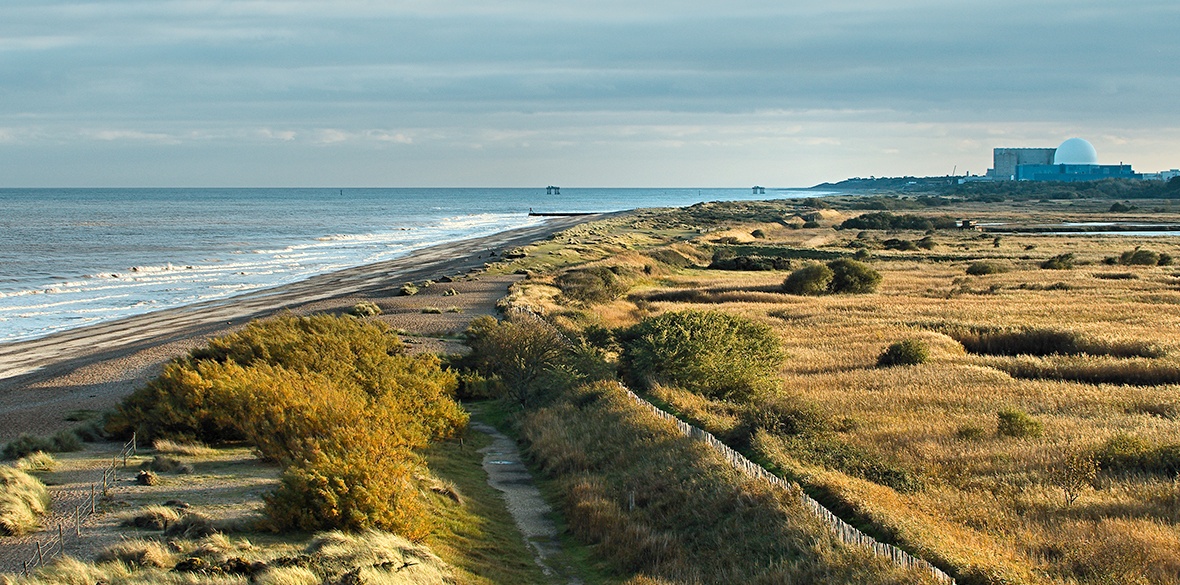
We decided this was the place for us and we’d take our break exploring this unfamiliar location near to the Suffolk coast.
Sadly when we got there Doggerland had gone. Today the place is totally submerged beneath the chilly waters of the North Sea and has been for several thousand years.
Doggerland once joined the east coast of England with the coastal regions of the Netherlands, Germany and Denmark.
It reached England at what is now the Norfolk, Suffolk and Essex coast.
In was once an area of land occupied by all kinds of exotic prehistoric animals including mammoths, woolly rhinoceros and lions and a rich habitat with much human habitation.
Around 8,000 years ago Doggerland was flooded by rising sea levels. It was gradually reduced to low-lying islands before it finally disappeared beneath the North Sea’s waters.
Today the North Sea is 400ft (120m) deeper than it was all those years ago.
The lost location takes its name from the Dogger Bank, which was in turn named after 17th-century Dutch fishing boats called doggers.
Dogger is still mentioned as a sea area on that amazing poem that is the radio shipping forecast. Dogger is sandwiched between Forties, Humber, Fisher and German Bight.
In 1931 a trawler operating east of the Wash dragged up a barbed fishhook or harpoon carved from deer antler.
It was subsequently dated to a time when this area of the seabed was tundra.
Since then vessels have dragged up remains of mammoths, lions and many other exotic and extinct animals.
They have also found more prehistoric tools, weapons and other artefacts of human settlement.
Julia Blackburn’s wonderful book, Time Song: Searching for Doggerland, is full of amazing stories. One that made me smile was when she found a human skull in the crumbling cliffs at Dunwich.
She took the skull to the local museum where the curator told her it was too old to be of interest to the police but too new to have archaeological value so she could take it home.
Even today the North Sea is still taking back much of this coastline.
At Covehithe, country lanes run towards the sea and then fall away suddenly, abruptly tumbling into the sea, a few more yards every winter.
Throughout the Mesolithic period Doggerland was the richest hunting, wild-fowling and fishing ground in the whole of Europe.
Then between 8,000 and 8,500 years ago it was lost beneath the waves, cutting off what was previously the British peninsula from the European mainland.
The Dogger Bank, the highest parts of Doggerland, remained an island until around 7,000 years ago.
At very low tides parts of the bank still dry out and occasional football and cricket matches are played on the sands.
Edwardian sailing barges would deliberately run aground and dry out to fill their holds with sand and gravel to ship home for building work.
Recently, work by marine scientists discovered that the final flooding 8,000 years ago was caused by a huge tsunami generated by a submarine landslide off the Norwegian coast.
The landslide was known as the Storegga Slide and the tsunami tidal wave it caused would have had a catastrophic impact on the coastal Mesolithic population of the time.
Also about 8,500 years ago, a massive glacial freshwater lake in North America suddenly drained into the ocean.
What had been gradual sea-level rise accelerated, and seas rose some metres in decades.
Doggerland was transformed from a temperate, forested plain into an estuarial wetland dotted by drier highlands.
As the landscape changed, the diet of its residents did, too, shifting from land animals’ meat to freshwater fish. Britain finally became separated from the continent.
In the 1990s, professor in prehistoric archaeology Bryony Coles named the now underwater landmass Doggerland and made some of the first hypothetical maps of the area.
As well as research into Doggerland, Coles has also done extensive research into wetland archaeology, particularly in the Somerset Levels.
With her husband John she established a whole new branch of archaeology focusing on wetlands.
Coles roved distinctive marks on ancient preserved wood found in the Somerset Levels were made by beavers, not humans, thus proving beavers were once common native British animals.
For years archaeologists have speculated on Doggerland’s existence from bones dredged by fisherfolk all over the North Sea, but it’s only since oil-well drillings and offshore windfarm construction sites we have been able to recreate what lost Doggerland really looked like.
We now know Doggerland was once occupied by all kinds of exotic animals, including mammoths, woolly rhinoceros and lions. Its first humans were hunter-gatherers who eventually became settled farmers.
Since 2015 Bradford University has run a project called Europe’s Lost Frontiers. This is mapping the prehistoric landscapes of Doggerland.
Core drillings have provided sedimentary DNA as well as conventional environmental data and these have confirmed many human settlements.
Across the North Sea in the Netherlands they are just as keen on finding out about Doggerland.
In 2013 Dutch nurse and beach-comber Willy van Wingerden found her first woolly mammoth tooth.
Van Wingerden has since picked up over 500 ancient finds, including Neanderthal tools made of river cobbles and bone fishhooks.
As well as human remains thousands of years old, she has found a complete juvenile mammoth skull.
In 2015, van Wingerden found a flint flake with a simple tar handle. It turned out to be a Neanderthal hand tool at least 50,000 years old.
These and many other findings suggest humans lived in Doggerland for many thousands of years.
Tools and other relics 800,000 years old suggest occupation by Homo antecessor, a form of early human.
This makes Doggerland the home of some of the earliest human activity in the world, perhaps for over a million years.
So did we find our wonderful new holiday destination? Well, not really — no mammoth bones or flint axes for us on our cobbled beach walks.
What we did find were beautiful beaches — ideal for combing, marshland, boats, wildfowl and waders and seals. All this and more craft shops than anybody needs.
We ate plenty of oysters, lobsters, crabs and other local fish often washed down with local English sparkling wine.
We even found the best brown bread we had ever tasted. A local baker has developed his Trencher loaf from evidence found at Weststow Anglo-Saxon village.
The seedy bread has an aromatic crust — just like they used to eat millennia ago in Doggerland.